Page digital maps and plans gis panorama. Gis panorama - miscellaneous. Performing logical and mathematical operations on lists of objects
1. Import and view:
- vector maps from SXF, TXF, OGC GML (XML), KML (Google), DXF, etc. formats;
- raster data (RSW, BMP, JPEG, GeoTIFF, TIFF), multispectral images (GeoTIFF);
- DEMs, quality matrices, geological matrixes of layers, TIN-models, laser scanning data (point cloud in MTD format);
- custom maps, work area.

2. Creation of new maps with automatic filling of parameters by EPSG code or from a list of parameters in XML format.
3. Export maps to SXF, DXF, OGC GML formats.
4. Multi-user work with data with access control through connection to the GIS Server.
5. Map editing:
- creation of simple objects and objects with subobjects;
- creation of objects according to the type selected from the panel of layouts of created objects;
- creating, deleting and moving object contour points;
- moving and rotating objects;
- drawing simple lines and polygons;
- input of label texts and attribute values in UNICODE.
Combining and editing vector maps of different projections in one document.


6. Support for popular geoportals, which allows displaying user maps on top of images received from Google (Satellite), Google (Map), Google (Landscape), Yahoo! (Satellite), Yahoo! (Map), OpenStreetMap (Map), Yandex (Satellite), Yandex (Map), Rosreestr, geoportal of the Cadastral Map of Ukraine, Kosmosnimki and others. The list of geoportals is constantly expanding and can be supplemented by system users.
Import data from servers using the OGC WMS and OGC WFS protocols.
7. Connection to a GPS/GLONASS receiver for solving navigation tasks. Managing data with tasks "Map Legend" And "Atlas of maps".


8. Preparation and printing complex reports, including maps, graphics, multi-line text with different attributes, embedded office documents and tables, borders, coordinate grids and other elements. Printing an electronic map on various output devices and output in PostScript. Preview of a document prepared for printing, setting the parameters for printing small runs of cards.
The GIS includes over 100 different tasks containing a variety of tools for processing spatial information about the area.
- Flexible spatial data classification system, smart symbols;
- Support for international standards OGS, ISO 19100, IHO, ICAO and others for the exchange and display of spatial data;
- Support for a database of parameters of national coordinate systems according to the EPSG code;
- Support for common spatial data exchange formats;
- Combining data from databases and data from open sources using web browser protocols;
- A large set of extension modules for special tasks: land and real estate cadastre, urban planning, ecology, agro-enterprise management, air navigation, communication network management and others;
- Professional editor of digital topographic, marine, aeronautical and other maps and city plans;
- 3D analysis complex, Report editor, Form designer, GPS\GLONASS monitor and many other built-in tasks;
- Collective remote work with data, access control and data protection based on cloud technologies;
- Formation of graphic images that clearly illustrate the ratio of the values of the selected characteristic for individual objects of the electronic map;
- Generalization of digital maps - automated creation of small-scale maps from large-scale maps;
- Preparation of digital maps for publication;
- Collection of data for the maintenance of the land and real estate cadastre;
- Support for international standards for the display and storage of maritime (IHO) and aeronautical (ICAO) data.
Key features
Advanced tools for editing vector and raster maps terrain and applying applied graphic information to the map. Support for several dozen different map projections and coordinate systems, including 42 years, PZ-90, WGS-84 and others. Support for the entire scale range - from the floor plan to the space navigation map of the Earth. The volume of one vector map can take several TB. One raster or matrix map can take up to 8 GB.
Import and View
- vector maps from formats (SXF, TXF, OGC GML (XML), KML (Google), Arinc 424, etc.);
- raster data (RSW, BMP, JPEG, GeoTIFF, TIFF, IMG), multispectral images (GeoTIFF);
- DEMs, quality matrices, geological matrixes of layers, TIN-models, laser scanning data (point cloud in MTD format);
- custom maps, work area.
Creating new maps
Creation of new maps with automatic filling of projection parameters by EPSG code or from a list of parameters in XML format.
Map export to SXF, MIF\MID, SHP\DBF (Shape), OGC GML (XML), KML (Google), DXF, S57 formats.
Professional map editor (about 120 modes)
General quality control of a vector map and control of absolute heights.
Data transformation(vector map transformation, raster data transformation, image transformation, etc.)
Data processing(pre-tile preparation of OpenStreetMap data, building a mathematical basis, summarizing adjacent sheets, merging data, building contours using a DEM)


Data control and correction(correction of object metrics, construction of labels according to the semantics of objects, control of label metrics, viewing statistics on objects, etc.)
Geodetic problems(calculation of MSC parameters by a set of points, calculation of datum parameters by a set of points)
Designed to create labels according to the semantics of objects. In the process of creating signatures, their mutual position is analyzed to exclude the intersection of signatures.


Construction of three-dimensional terrain models, moving through them in real time. The surface of the model can be formed using vector, raster or matrix maps, the construction of an image of the objects of an electronic map, the choice of textures and coating material are provided.
Performing logical and mathematical operations on lists of objects
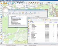
Construction of intersections or unions of contours of objects of one list with another. Building a common area around the objects included in the list. Selection on the map of objects of one list that have a certain spatial relationship with objects of another list (occurrence, intersection, contiguity, removal within a given distance, etc.), etc.
Network model and network analysis.
The tasks of network analysis are to find the minimum route between nodes, taking into account the values of the semantic characteristics of the network edges and to find objects within a given distance from the specified node (distance graph). The network data model (road graph) is presented in the form of a user map containing objects: a network node and an edge with semantic characteristics, which store information about the network connectivity and attributes for solving network analysis problems.

Map Atlas - map manager
Map atlas support (fast transition between overlapping maps of different scales, coordinate systems and projections. With the help of an additional module - "Map Manager" convenient systematization of metadata about cartographic resources in your local network is available.

Interactive design of information systems based on the built-in constructor of forms, reports, SQL queries. Various types of links between map objects and database table records (from one to one to many to many). Tools for data analysis and construction of graphs, diagrams, thematic mapping, geocoding.
Creation of charts on the map based on the values of semantic characteristics or values of selected fields of database tables. When creating cartograms, there is a possibility of proportional and non-proportional distribution of ranges of values of attributive characteristics.

Calculations on the plane and in space
Calculations on a plane and in space, taking into account projection distortions, curvature of the Earth, three-dimensional coordinates, matrixes of heights and qualitative characteristics. Performing overlay operations on multiple objects. Control of topological correctness of data. Search and selection of objects according to the values of attribute characteristics, size, spatial position relative to other objects.

GIS "Panorama" allows you to create and analyze surface models that reflect the change in a given characteristic. The surface model can display such terrain properties as terrain heights, pollution concentration, precipitation, radiation level, distance from a given object, and others. The model can be formed as a matrix of heights (MTW) or a matrix of qualities (MTQ).

Electronic map system "PANORAMA"
GIS "PANORAMA" is a database management system for electronic maps designed to create and update vector, raster and matrix maps, use them to solve a wide range of applied tasks, as well as to develop applications.
The system allows you to:
Maintaining a cartographic database;
Maintaining an attributive (semantic) database;
Establishment and maintenance of links between cartographic objects and attributive (semantic) databases;
Maintaining classifiers and reference books;
Formation and output of reporting, analytical and presentation materials;
Graphical information in the system can have a raster or vector representation. For vector data, there is the possibility of layered representation. A layer set can contain up to 255 layers, each of which contains a specific set of vector objects (up to 65,535 types of objects in total). Sets of geo-objects form cartographic compositions, which are displayed by conventional symbols of the appropriate scale. Each object can be associated with certain attributive information (up to 65,535 characteristics). All information about symbols is contained in the classifier, which can be edited by the user.
GIS "PANORAMA" allows you to combine individual nomenclature sheets into an area (up to 255 sheets in one area). In the process of creating a map, the issues of generalization of the cartographic image depending on the given scale are solved. All cartographic and semantic information is stored in the SXF exchange format, it is possible to convert data into exchange formats of other systems: F1M, F20V, DXF, F20S, etc.
GIS "PANORAMA" is implemented in the form of dynamic libraries with a documented interface, which allows you to use individual libraries in C++, Delphi, Visual Basic, Visual FoxPro, and so on.
Together with the GIS "PANORAMA" additional modules can be supplied to solve some applied problems. R
System of accounting and registration of land users (SUZ)
Allows you to maintain databases:
Land plots with their main properties (encumbrance, restriction on use, etc.)
Register of land holdings;
Land owners
Register of land users;
Land relations
Register of land relations;
Building a matrix of heights. The matrix may contain heights that reflect the absolute or total terrain. The absolute relief is built on the basis of data on the earth's surface, represented by contour lines, elevation marks, water edges, etc. The total relief is created on the basis of the absolute relief, taking into account data on terrain objects (forests, settlements, power lines, etc.) . The matrix of heights is formed on a separate sheet, area of work or terrain. DEM displaying is possible in the form of 2D or 3D representations. This procedure serves as the basis for solving the problems of predicting flooding or drainage of territories.
Complex "Geodesy". This is a specialized complex for solving applied problems and processing data from field measurements. It is designed for automated processing of data from field geodetic works and subsequent calculations, namely, for building and adjusting data from polygonometric and theodolite traverses.
The advantages of GIS "PANORAMA" include low requirements for hardware. Even new versions can function normally on a computer WITH 386 processor and 4 megabytes of RAM.
GIS Panorama - 3.0 out of 5 based on 3 votes


