What an era of geographical discoveries. Great geographical discoveries: causes, events, consequences
Great geographical discoveries - an era in the history of the world that began in the 15th century and lasted until the 17th century.
During era of great geographical discoveries Europeans discovered new lands and sea routes to Africa, America, Asia and Oceania in search of new trading partners and sources of goods that they used in great demand in Europe.
Historians generally associate the "Great Discovery" with the pioneering long sea voyages of Portuguese and Spanish explorers in search of alternative trade routes to the "Indies" for gold, silver and spices.
Sasha Mitrakhovich 22.12.2017 08:07

The main reasons for the Great Geographical Discoveries
- Depletion of precious metal resources in Europe; overpopulation of Mediterranean areas
- With the fall of Constantinople in the 15th century. The land routes along which eastern goods (spices, fabrics, jewelry) reached Europe were captured by the Ottoman Turks. They blocked the previous trade routes of Europeans with the East. This necessitated the search for a sea route to India.
- Scientific and technological progress in Europe (navigation, weapons, astronomy, printing, cartography, etc.)
- The desire for wealth and fame.
- In open lands, Europeans founded colonies, which became a source of enrichment for them.
Sasha Mitrakhovich 22.12.2017 08:07

Great geographical discoveries. Briefly
- 1492 - discovery of America by Columbus
- 1498 - Vasco da Gama discovered a sea route to India around Africa
- 1499-1502 - Spanish discoveries in the New World
- 1497 - John Cabot discovers Newfoundland and Labrador
- 1500 - discovery of the mouth of the Amazon by Vicente Pinzon
- 1519-1522 - Magellan's first circumnavigation of the world, discovery of the Strait of Magellan, Mariana, Philippine, Moluccas Islands
- 1513 - discovery of the Pacific Ocean by Vasco Nunez de Balboa
- 1513 - Discovery of Florida and the Gulf Stream
- 1519-1553 - discoveries and conquests in South America by Cortes, Pizarro, Almagro, Orellana
- 1528-1543 - Spanish discoveries of the interior of North America
- 1596 - discovery of the island of Spitsbergen by Willem Barents
- 1526-1598 - Spanish discoveries of the Solomon, Caroline, Marquesas, Marshall Islands, New Guinea
- 1577-1580 - second voyage around the world by the Englishman F. Drake, discovery of the Drake Passage
- 1582 - Ermak’s campaign in Siberia
- 1576-1585 - English search for the northwest passage to India and discovery in the North Atlantic
- 1586-1629 - Russian campaigns in Siberia
- 1633-1649 - discovery by Russian explorers of the East Siberian rivers to the Kolyma
- 1638-1648 - discovery of Transbaikalia and Lake Baikal by Russian explorers
- 1639-1640 - exploration by Ivan Moskvin of the coast of the Sea of Okhotsk
- The last quarter of the 16th century - the first third of the 17th century - the development of the eastern shores of North America by the British and French
- 1603-1638 - French exploration of the interior of Canada, discovery of the Great Lakes
- 1606 - independent discovery of the northern coast of Australia by the Spaniard Quiros and the Dutchman Janson
- 1612-1632 - British discoveries of the northeastern coast of North America
- 1616 - discovery of Cape Horn by Schouten and Le Mer
- 1642 - Tasman's discovery of the island of Tasmania
- 1643 - Tasman discovers New Zealand
- 1648 - Dezhnev’s discovery of the strait between America and Asia (Bering Strait)
- 1648 - discovery of Kamchatka by Fedor Popov
Sasha Mitrakhovich 22.12.2017 08:07

In the photo: Portrait of Vasco Nunez de Balboa by an unknown artist.
At the beginning of the 16th century, Europeans continued to “discover” the Earth; Researchers attribute this time to the first period of the Age of Discovery. The main role was then played by the Spaniards and Portuguese, rushing to the unexplored lands of America, Africa and Asia.
In 1513, the Spaniards built their first settlements in America, steadily moving from east to west. They were attracted by stories about the mythical Eldorado, buried in gold and precious stones.
In September, the enterprising conquistador Vasco Nunez de Balboa, with 190 Spanish soldiers and many Indian guides, set out from the city of Santa Maria la Antigua, which he had founded three years earlier. He had been looking for success in America for about fifteen years, skillfully combining “carrot and stick” in his relationships with the local population. He could caress and give gifts, or he could, in anger, hunt down an Indian he disliked with dogs, which brought indescribable horror to the aborigines.

For more than three weeks, the detachment literally “struggled” through mountains covered with thickets of vines and ferns, suffering from fever in the swampy lowlands and repelling attacks from warlike local residents. Finally, having crossed the Isthmus of Panama, from the top of Mount Balboa he saw the vast expanse of the sea. Entering the water with a drawn sword in one hand and a Castilian banner in the other, the conquistador declared these lands the possessions of the Castilian crown.
Having received a pile of pearls and gold from the natives, Balboa was convinced that he had found the fairyland from the stories about Eldorado. He called the sea he reached “Southern”.
So Vasco Nunez de Balboa discovered Pacific Ocean . continued.
By the way, when Balboa in 1510 persuaded the first Spanish colonists to follow him into the interior of the mainland, among the latter was the later famous Francisco Pizarro. Then Pizarro did not want to go with the future discoverer of the Pacific Ocean. Pizarro's finest hour came twenty years later. In 1532, he conquered Peru, the Inca Empire, becoming the owner of an unprecedented amount of gold.
Sasha Mitrakhovich 22.12.2017 08:14

Throughout modern history, the world familiar to Europeans (that is, for them in general, “the world”) became larger and larger. In 1642, this “world” was replenished with another territory - it was called New Zealand. This is where it ended.
New Zealand was discovered by Abel Tasman
Abel Tasman was a very inquisitive and purposeful person. How else can we explain the miraculous transformation of a child from a poor Dutch family into a real “sea wolf”, a famous navigator, a discoverer of new lands? Self-taught, born in 1603, at the age of thirty (that is, quite serious) he entered the service of the Dutch East India Company as a simple sailor, and already in 1639 he commanded a ship sent to establish trade contacts with Japan.
Dutch merchants in those days dreamed of expanding their sphere of influence; this was the golden age of the Dutch bourgeoisie. There were rumors of a mysterious land south of Australia, full of untold riches; it was called the Southern Continent. The Dutch East India Campaign sent Tasman to look for this continent. He did not find the mythical continent, but he discovered New Zealand. This often happened in that era - remember how Columbus accidentally discovered America.
The two ships left Batavia in August 1642. Having rounded Australia from the south and heading east, on November 24 Tasman discovered an island later named after him (Tasmania), and on December 13 - new land: This was the South Island of New Zealand. Dropping anchor in the bay, he met the aborigines. The meeting was not without tragedy - Maori warriors killed four Europeans, for which the bay received the gloomy nickname of Murder Bay from Tasman.
Great geographical discoveries of European travelers of the late 15th century. - mid 17th century were the result of the rapid development of productive forces in Europe, the growth of trade with the countries of the East, and the shortage of precious metals in connection with the development of trade and money circulation.
It is known that even in ancient times, Europeans visited the coast of America, traveled along the coast of Africa, etc. However, a geographical discovery is considered not only a visit by representatives of any civilized people to a previously unknown part of the Earth. This concept includes the establishment of a direct connection between the newly discovered lands and the centers of culture of the Old World. Only the discovery of America by H. Columbus laid the foundation for broad connections between the open lands and Europe; the travels of Vasco da Gama to the shores of India served the same purpose. trip around the world F. Magellan.
Great geographical discoveries became possible as a result of significant advances in the development of science and technology in Europe. At the end of the 15th century. The doctrine of the sphericity of the Earth became widespread, and knowledge in the field of astronomy and geography expanded. Navigation instruments (compass, astrolabe) were improved, new type sailing ship - caravel.
Portuguese navigators were the first to begin searching for new sea routes to Asia. In the early 60s. 15th century they captured the first strongholds on the coast of Africa, and then, moving south along its western coast, discovered the Cape Verde Islands and the Azores. At this time, Prince Henry (Enrique), nicknamed the Navigator, became a tireless organizer of long voyages, although he himself rarely set foot on a ship. In 1488, Bartolomeu Dias reached the Cape of Good Hope in southern Africa. The knowledge acquired by the Portuguese as a result of their travels gave sailors from other countries valuable information about ebb and flow, the direction of winds and currents, and made it possible to create more accurate maps on which latitudes, lines of the tropics and the equator were plotted. These maps contained information about previously unknown countries. Previously widespread ideas about the impossibility of sailing in equatorial waters were refuted, and the fear of the unknown, characteristic of medieval people, gradually began to recede.
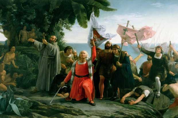
At the same time, the Spaniards also rushed to search for new trade routes. In 1492, after the capture of Granada and the completion of the reconquista, the Spanish King Ferdinand and Queen Isabella accepted the project of the Genoese navigator Christopher Columbus (1451-1506) to reach the shores of India, sailing west. Columbus's project had many opponents, but it received the support of scientists at the University of Salaman, the most famous in Spain, and, no less significantly, among the business people of Seville. On August 3, 1492, from Palos - one of the best ports on the Atlantic coast of Spain - Columbus's flotilla set sail, consisting of 3 ships - "Santa Maria", "Pinta" and "Nina", the crews of which numbered 120 people. From the Canary Islands, Columbus headed west. On October 12, 1492, after a month of sailing in the open ocean, the fleet approached a small island from the Bahamas group of islands, then named San Salvador. Although the newly discovered lands bore little resemblance to the fabulously rich islands of India and China, until the end of his days Columbus was convinced that he had discovered islands off the eastern coast of Asia. During the first voyage, the islands of Cuba, Haiti and a number of smaller ones were discovered. In 1492, Columbus returned to Spain, where he was appointed admiral of all discovered lands and received the right to 1/10 of all income. Subsequently, Columbus made three more voyages to America - in 1493-1496, 1498-1500, 1502-1504, during which part of the Lesser Antilles, Puerto Rico, Jamaica, Trinidad, etc. were discovered; part of the Atlantic coast of the Central and South America. Although the open lands were very fertile and favorable for life, the Spaniards did not find gold there. Doubts arose that the newly discovered lands were India. The number of Columbus's enemies among the nobles grew, dissatisfied with the fact that he severely punished the expedition members for disobedience. In 1500, Columbus was removed from his post and sent to Spain in chains. He managed to restore his good name and make another trip to America. However, after returning from his last journey, he was deprived of all income and privileges and died in poverty.
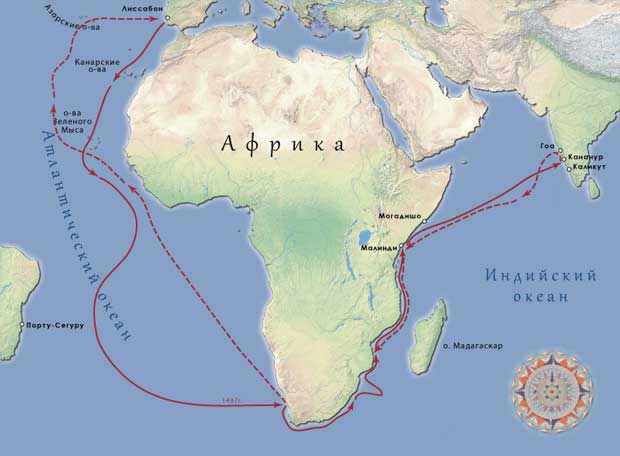
Columbus's discoveries forced the Portuguese to hurry up. In 1497, the flotilla of Vasco da Gama (1469-1524) sailed from Lisbon to explore routes around Africa. Having rounded the Cape of Good Hope, he entered the Indian Ocean. Moving north along the coast, the Portuguese reached the Arab trading cities of Mozambique, Mombasa and Malindi. With the help of an Arab pilot, on May 20, 1498, Vasco da Gama's squadron entered the Indian port of Calicut. In August 1499 his ships returned to Portugal. The sea route to the land of fabulous riches was open. From now on, the Portuguese began to equip up to 20 ships annually for trade with India. Thanks to their superiority in weapons and technology, they managed to oust the Arabs from there. The Portuguese attacked their ships, exterminated their crews, and devastated cities on the southern coast of Arabia. In India, they captured strongholds, among which the city of Goa became the main one. The spice trade was declared a royal monopoly; it provided up to 800% of profits. At the beginning of the 16th century. The Portuguese captured Malacca and the Moluccas. In 1499-1500 by the Spaniards and in 1500-1502. The coast of Brazil was discovered by the Portuguese.
In the 16th century Portuguese sailors mastered the sea routes in the Indian Ocean, reached the shores of China, and were the first Europeans to set foot on Japanese soil. Among them was Fernand Pinto, the author of travel diaries, where he was given detailed description newly opened country. Before this, Europe had only fragmentary and confusing information about Japan from the “Book of Marco Polo,” the famous Venetian traveler of the 14th century, who, however, never reached the Japanese islands. In 1550 their image from modern name first appeared on a Portuguese navigation chart.
In Spain, after the death of Columbus, expeditions continued to be sent to new lands. At the beginning of the 16th century. traveled to the Western Hemisphere Amerigo Vespucci (1454-1512) - a Florentine merchant who served first with the Spanish and then with the Portuguese king, a famous navigator and geographer. Thanks to his letters, the idea that Columbus discovered not the coast of India, but a new continent, gained popularity. In honor of Vespucci, this continent was named America. In 1515, the first globe with this name appeared, and then atlases and maps. Vespucci's hypothesis was finally confirmed as a result of Magellan's trip around the world (1519-1522). The name of Columbus remained immortalized in the name of one of the Latin American countries - Colombia.
The proposal to reach the Moluccas by rounding the American continent from the south, expressed by Vespucci, interested the Spanish government. In 1513, the Spanish conquistador V. Nunez de Balboa crossed the Isthmus of Panama and reached the Pacific Ocean, which gave hope to Spain, which did not receive much benefit from Columbus's discoveries, to find a western route to the shores of India. This task was destined to be completed by the Portuguese nobleman Ferdinand Magellan (c. 1480-1521), who had previously visited the Portuguese possessions in Asia. He believed that the coast of India lay much closer to the newly discovered continent than it actually was. On September 20, 1519, a squadron of five ships with 253 crew members, led by Magellan, who had entered the service of the Spanish king, left the Spanish harbor of San Lucar. After months of sailing across the Atlantic Ocean, Magellan reached the southern tip of America and passed through the Strait (later called the Strait of Magellan), which separated the mainland from Tierra del Fuego. After three weeks of sailing through the strait, the squadron entered the Pacific Ocean, passing off the coast of Chile. On December 1, 1520, land was last seen from ships. Magellan headed north and then northwest. For three months and twenty days, while the ships sailed on the ocean, he was calm, and therefore Magellan called him Quiet. On March 6, 1521, the expedition approached small inhabited islands (Mariana Islands), and after another 10 days it found itself at the Philippine Islands. As a result of Magellan's voyage, the idea of the spherical shape of the Earth was confirmed, it was proved that between Asia and America lies a huge expanse of water - the Pacific Ocean, which most of globe occupied by water, not land, that there is a single World Ocean.
On April 27, 1521, Magellan died in a skirmish with the natives on one of the Philippine islands. His companions continued sailing under the command of Juan Sebastian El Cano and reached the Moluccas and Indonesia. Almost a year later, the last of Magellan's ships set off for their native shores, taking on board a large cargo of spices. On September 6, 1522, the ship Victoria returned to Spain; Of the entire crew, only 18 people survived. "Victoria" brought so many spices that their sale made it possible not only to cover all the expenses of the expedition, but also to make a significant profit. For a long time No one followed Magellan's example, and only in 1578-1580. The second voyage around the world in history was made by the English pirate Francis Drake, who robbed the Spanish colonies on the Pacific coast of America along the way.
In the 16th century - 1st half of the 17th century. The Spaniards explored the northern and western coasts of South America, penetrated into the interior and, in a bloody struggle, conquered the states (Mayans, Aztecs, Incas) that existed on the territory of Yucatan, present-day Mexico and Peru (see America's most ancient and ancient civilizations). Here the Spanish conquerors, primarily Hernán Cortés and Francisco Pizarro, seized enormous treasures accumulated by the rulers and priests of these states. In search of the fabulous country of El Dorado, the Spaniards explored the basin of the Orinoco and Magdalena rivers, where rich deposits of gold, silver and platinum were also discovered. The Spanish conquistador Jimenez de Quesada conquered what is now Colombia.
In the 2nd half of the 16th century. - early 17th century The Spaniards made a number of Pacific expeditions from the territory of Peru, during which the Solomon Islands (1568), Southern Polynesia (1595), and Melanesia (1605) were discovered.
Long before the era of the Great Geographical Discoveries, the idea of the existence of a “Southern Continent”, of which the islands of Southeast Asia were considered a part, arose and became especially popular during the discoveries. She spoke out in geographical works, and the mythical continent was even put on maps under the name “Terra Australis Incognita” - “Unknown Southern Land”. In 1605, a Spanish squadron of 3 ships sailed from Peru under the command of P. Quiros, who discovered a number of islands, one of which he mistook for the coast of the mainland. Abandoning two ships to the mercy of fate, Quiros returned to Peru and then sailed to Spain to secure the rights to rule the new lands. But it soon turned out that he was mistaken. The captain of one of the two abandoned ships, the Portuguese L.V. de Torres, continued sailing and found out that Quiros had discovered not the mainland, but a group of islands (New Hebrides). Sailing west, Torres passed along the southern coast of New Guinea through the strait later named after him, and discovered Australia lying to the south. There is evidence that on the coast of the new continent back in the 16th century. The Portuguese and the Dutch landed shortly before Torres, but this was not known in Europe. Having reached the Philippine Islands, Torres reported the discovery to the Spanish government. However, fearing competitors and lacking the strength and means to develop the new land, the Spanish administration hid information about this discovery.
In the 1st half of the 17th century. The search for the “Southern Continent” was carried out by the Dutch, who explored a significant part of the coast. In 1642, Abel Janszon Tasman (1603-1659), sailing from the coast of Indonesia to the west, circumnavigated Australia from the south, discovering an island called Tasmania. Only 150 years later during Seven Years' War(1756-1763) the British captured Manila, the center of Spanish possessions in the Philippines, and found news of the discovery of Torres in the Spanish archives. In 1768, the English navigator D. Cook explored the shores of Oceania and Australia and again passed through the Torres Strait. He subsequently recognized Torres' priority in the discovery of Australia.
In 1497-1498 English sailors reached the northeastern coast of North America and discovered Newfoundland and Labrador. In the 16th-17th centuries. the British and French continued to send expedition after expedition here; many of them sought to find the northwest passage from Atlantic Ocean in Quiet. At the same time, a search was underway for a northeastern route to India - through the Arctic Ocean.
In the 16th-17th centuries. Russian explorers explored the northern coasts of the Ob, Yenisei and Lena and mapped the contours of the northern coast of Asia. In 1642, Yakutsk was founded, which became the base for expeditions to the Arctic Ocean. In 1648, Semyon Ivanovich Dezhnev (c. 1605-1673), together with Fedot Popov, left Kolyma on 6 ships and went around the Chukotka Peninsula, proving that the Asian continent is separated from America by a strait. The outlines of the northeastern coast of Asia were refined and plotted on maps (1667, “Drawing of the Siberian Land”). But Dezhnev’s report on the discovery of the strait lay in the Yakut archive for 80 years and was published only in 1758. In the 18th century. The strait discovered by Dezhnev was named after the Danish navigator in the Russian service, Vitus Bering, who in 1728 opened the strait for the second time. In 1898, in memory of Dezhnev, a cape at the northeastern tip of Asia was named after him.
In the 15th-17th centuries. As a result of bold sea and land expeditions, a significant part of the Earth was discovered and explored. Paths were laid that connected distant countries and continents. Great geographical discoveries marked the beginning of the creation of the colonial system (see Colonialism), contributed to the formation of the world market and played an important role in the formation of the capitalist economic system in Europe. For newly discovered and conquered countries, they brought mass extermination of the population, the imposition of the cruelest forms of exploitation, and the forced introduction of Christianity. The rapid decline of the native American population led to the importation of African slaves and widespread plantation slavery (see Slavery, Slave Trade).
American gold and silver poured into Europe, causing there a frantic rise in prices for all goods, the so-called price revolution. This primarily benefited the owners of factories, capitalists and merchants, since prices rose faster than wages. The “price revolution” contributed to the rapid ruin of artisans and handicraftsmen; in the village, the nobles and wealthy peasants who sold food at the market benefited most from it. All this contributed to the accumulation of capital.
As a result of the Great Geographical Discoveries, Europe's connections with Africa and Asia expanded, and relations with America were established. The center of world trade and economic life has shifted from Mediterranean Sea into the Atlantic Ocean.
Any modern man knows that there are six continents on Earth, this number includes North America, South America and Australia. They relate to such a historical phenomenon as the Great Geographical Discoveries. In this article we will briefly look at them!
Nowadays, it is difficult to imagine life without such wonderful places as New Zealand and the Hawaiian Islands. Now almost anyone has the opportunity to visit these parts of the planet for relatively little money. Has this always been the case? Of course not. There was a time when people did not even know about the existence of these places.
Periodization of the Great Geographical Discoveries
If we talk about defining the period of the Great Geographical Discoveries, they occurred at the end of the 15th – mid-17th centuries. Let's see why these discoveries are called “Great”. This name is due to the fact that they had special significance for the destinies of our world in general, and Europe in particular.
Great geographical discoveries were made at their own peril and risk, because travelers did not know what exactly awaited them. The only thing they clearly understood was the importance of their wanderings. There were enough reasons. Let's take a closer look at some of them.
The Age of Discovery is divided into two periods:
- Spanish-Portuguese period (late 15th – mid-16th century) The most famous and, of course, the most important discoveries during this period were: the discovery of America (the first expedition of Christopher Columbus in 1492); discovery of the sea route to India by Vasco da Gamma (1497–1498); F. Magellan's first circumnavigation of the world (1519–1522).
- The period of Russian and Dutch discoveries (mid-16th – mid-17th centuries). It usually includes: The discovery by Russians of all of Northern Asia (from Ermak’s campaign to the voyage of Popov-Dezhnev in 1648), the Dutch Pacific expeditions and the discovery of Australia.
Origins of the Great Geographical Discoveries
There were only three main reasons for the Great Geographical Discoveries. Firstly, they were determined by the economic development of Europe. Towards the end of the 15th century. European trade with the countries of the East was experiencing a great crisis. The crisis was due to the fact that a new harsh state appeared in the vast expanses of Asia Minor - the Ottoman Empire.

Therefore, the trade routes of the Mediterranean were completely cut off, because previously they passed through the disappeared Byzantium. In the 15th century in countries Western Europe people needed gold and silver as a means of circulation, and because of the crisis they felt an acute shortage. The impoverished nobility at that time was in search of both gold itself and new trade routes. This nobility made up the bulk of the conquerors, who were also called conquistadors. The state, realizing its precarious position, was forced to make concessions and allocate funds for sea expeditions.
Secondly, an important reason for the Great Geographical Discoveries was Europe's significant advances in science and technology. First of all, the development in the construction of improved ships and also the navigation technology itself. In the XIV–XV centuries. The first caravel was created - a fairly fast ship that had spacious holds.


The importance of the caravel was that it was intended for ocean navigation. From a scientific point of view, at the same time, the hypothesis was approved that the Earth has the shape of a ball, which helped in orientation. Geographical maps were rewritten with new introductions, and the compass and astrolabe were greatly improved. All these discoveries took place along with, for example, the invention of clocks and chronology. For more details, see the article.
Great travelers and their geographical discoveries
Everyone knows that the great Spanish navigator H. Columbus in the 1490s discovered America, which was very important and necessary for Europe at that time. In total, he made four voyages to the “new land”. Moreover, his discoveries include: Cuba, Haiti, Jamaica, Puerto Rico, land from Dominica to the Virgin Islands, as well as Trinidad and the wonderful Bahamas. Columbus really wanted to discover India. Because for a long time in Europe, people believed that there was a lot of gold in fabulous India. By the way, these beliefs were started by the legendary Marco Polo.
But it so happened that Columbus discovered America.
And you will immediately ask: “Why then is America called “America” and not Colombia?! Where is the copyright!” I answer immediately: there are persistent rumors that a certain Amerigo Vespucci, one of the clerks of the house of Medici (who provided money for voyages across the oceans), discovered the continent of the New World a year and a half before Columbus. Everything seems to be ironclad, but unfortunately there is no evidence of this. If anyone knows, write in the comments, otherwise we haven’t figured it out with Newton yet 😉 But the country is named after Columbus - Colombia.
Other fun historical facts you can.
We also cannot forget about Ferdinand Magellan, who discovered the strait, which was later named after him. He became the first European to travel by sea from the Atlantic Ocean to the Pacific Ocean. But his most famous trip is around the world. The great Portuguese and Spanish navigator was awarded the title adelantado, translated as “pioneer,” whom the king himself directed to conquer new lands.

But not only the West participated in new discoveries, Russian expeditions were also quite important. The annexation of Siberia was of great importance at that time. It was started in 1581 by the campaign of a detachment of the well-known Cossack ataman Ermak Timofeevich. Ermak's campaign, with the help of government approval, contributed to the annexation of Western Siberia to the Russian state. Actually, from this time on, Siberia and the Far East became colonies of the Muscovite kingdom. These Europeans sailed the seas, died of scurvy and hunger..., and the Russians “without bothering” found another way.
One of the most significant was the discovery in 1648 of the strait between America and Asia, which was made by Semyon Dezhnev together with Fedot Alekseev (Popov).
Russian ambassadors played a significant role in improving maps and routes. The most famous include I.D. Khokhlov and Anisim Gribov. They participated in the description and study of routes to Central Asia.
Consequences of the Great Geographical Discoveries
Geographical discoveries led to certain world changes. Firstly, there was a “price revolution”. The value plummeted due to the influx of gold and silver, which led to an immediate rise in prices. This caused new economic problems. Second, world trade expanded significantly and began to strengthen.
This happened thanks to new products such as tobacco, coffee, cocoa, tea, rice, sugar and potatoes, which Europeans had not heard of before. Due to their inclusion in trade, the volume of trade increased greatly. Thirdly, the development of new lands and travel across the ocean contributed to the strengthening and improvement of international relations. The only thing negative consequence this was the beginning of colonization; everything else, in principle, had a positive effect on the world order.
In conclusion, I would like to say that the progress of mankind depends on many reasons, but the most important is the desire to improve living conditions. Thanks to the Great Geographical Discoveries, new lands were developed in a relatively short time, relations between peoples were established, and trade turnover was improved. The era of VGO went down in history as one of the most important events in the life of mankind.
Other topics on World History, and in video lessons you will find in
© Alexander Chudinov
Editing by Andrey Puchkov
This change occurred earlier, in Russia - later. The changes reflected increased production, which required new sources of raw materials and markets. They imposed new conditions on science and contributed to the general rise of the intellectual life of human society. Geography also acquired new features. Travel enriched science with facts. They were followed by generalizations. This sequence, although not absolutely noted, is characteristic of both Western European and Russian science.
The era of great discoveries of Western sailors. At the turn of the 15th and 16th centuries, outstanding geographical events took place over three decades: the voyages of the Genoese X. to the Bahamas, on, to the mouth of the Orinoco and on the coast of Central America (1492-1504); around the South - the city of Callicut (1497-1498), F. and his companions (Juan Sebastian Elcano, Antonio Pigafetta, etc.) around and around South Africa (1519-1521) - the first circumnavigation.
The three main search paths - and Magellan - ultimately had one goal: to reach by sea the richest space in the world - from and other areas of this vast space. In three different ways: directly to the west, around South America and around South Africa, the sailors bypassed the state of the Ottoman Turks, which blocked the Europeans' land routes to South Asia. It is characteristic that variants of these world routes were subsequently repeatedly used by Russian navigators.
The era of great Russian discoveries. The heyday of Russian geographical discoveries occurred in the 16th-17th centuries. However, the Russians collected geographical information themselves and through their Western neighbors much earlier. Geographical data (from 852) is contained in the first Russian chronicle - “The Tale of Bygone Years” by Nestor. Russian city-states, developing, were looking for new natural sources of wealth and markets for goods. Novgorod, in particular, grew richer. In the 12th century. Novgorodians reached the sea. Voyages began to the west to Scandinavia, to the north - to Grumant (Spitsbergen) and especially to the northeast - to Taz, where the Russians founded the trading city of Mangazeya (1601-1652). Somewhat earlier, movement to the east began overland, through Siberia (Ermak, 1581-1584).
The rapid movement into the depths of Siberia and towards the Pacific Ocean is a heroic feat. It took them a little more than half a century to cross the space from to the strait. In 1632 the Yakut fort was founded. In 1639, Ivan Moskvitin reaches the Pacific Ocean near Okhotsk. Vasily Poyarkov in 1643-1646. walked from to Yana and Indigirka, the first of the Russian Cossack explorers to sail along the Amur Estuary and the Sakhalin Bay of the Sea. In 1647-48. Erofey Khabarov passes to the Sungari. And finally, in 1648, Semyon Dezhnev goes around from the sea, discovers the cape that now bears his name, and proves that he is separated from North America by a strait.
Gradually, elements of generalization acquire great importance in Russian geography. In 1675, the Russian ambassador, the educated Greek Spafarius (1675-1678), was sent to the city with instructions to “depict all the lands, cities and the route on the drawing.” Drawings, i.e. maps were documents of state importance in Russia.
Early Russian is known for the following four of its works.
1. Large drawing Russian state. Compiled in one copy in 1552. The sources for it were “scribal books”. The Great Drawing has not reached us, although it was renewed in 1627. The geographer of Peter’s time V.N. wrote about its reality. Tatishchev.
2. Book of the Big Drawing - text for the drawing. One of the later copies of the book was published by N. Novikov in 1773.
3. The drawing of the Siberian land was drawn up in 1667. It has reached us in copies. The drawing accompanies the “Manuscript against the drawing”.
4. The drawing book of Siberia was compiled in 1701 by order of Peter I in Tobolsk by S.U. Remizov and his sons. This is the first Russian geographical map of 23 with drawings of individual regions and settlements.
Thus, in Russia, too, the method of generalizations first became cartographic.
In the first half of the 18th century. Extensive geographical descriptions continued, but with an increasing importance of geographical generalizations. It is enough to list the main geographical events to understand the role of this period in the development of domestic geography. Firstly, an extensive long-term study of the Russian coast of the Arctic Ocean by detachments of the Great Northern Expedition of 1733-1743. and the expeditions of Vitus and Alexei Chirikov, who, during the First and Second Kamchatka Expeditions, discovered the sea route from to (1741) and described part of the northwestern coast of this continent and some of the Aleutian Islands. Secondly, in 1724 it was established Russian Academy Sciences with the Geographical Department in its composition (since 1739). This institution was headed by the successors of Peter I, the first Russian geographers V.N. Tatishchev (1686-1750) and M.V. Lomonosov (1711-1765). They became organizers of detailed geographical research territories of Russia and themselves made a significant contribution to the development of theoretical geography, raising a galaxy of remarkable geographers and researchers. In 1742, M.V. Lomonosov wrote the first Russian work with theoretical geographical content - “On the Layers of the Earth.” In 1755, two Russian classic monographs on regional studies were published: “Description of the Land of Kamchatka” by S.P. Krashennikov and “Orenburg Topography” P.I. Rychkova. The Lomonosov period began in Russian geography - a time of reflection and generalizations.
By the 15th century, the prerequisites had developed in Europe for sailors to explore maritime spaces. Vessels appeared, designed specifically for the movement of European sailors. Technology is developing rapidly: by the 15th century, the compass and sea charts were improved. This made it possible to discover and explore new lands.
In 1492-1494 Christopher Columbus Bahamas, Greater and Lesser Antilles. By 1494 he reached America. Around the same time - in 1499-1501. – Amerigo Vespucci sailed to the shores of Brazil. Another famous one - Vasco da Gama - opens at the turn of the 15th-16th centuries. a continuous sea route from Western Europe to India. This contributed to the development of trade, which in the 15-16th centuries. played a primary role in the life of every state. X. Ponce de Leon, F. Cordova, X. Grijalva discovered the Gulf of La Plata, the Florida and Yucatan peninsulas.
The most important event
The most important event at the beginning of the 16th century it became Ferdinand Magellan and his team. Thus, it was possible to confirm the opinion that it has a spherical shape. Later, the strait through which his route passed was named in honor of Magellan. In the 16th century, South and North America were almost completely discovered and explored by the Spanish. Later, at the end of the same century, Francis Drake committed.
Russian sailors did not lag behind European ones. In the 16th-17th centuries. The development of Siberia and the Far East is rapidly progressing. The names of the discoverers I. Moskvitin and E. Khabarov are known. The basins of the Lena and Yenisei rivers are open. The expedition of F. Popov and S. Dezhnev sailed from the Arctic Ocean to the Pacific Ocean. Thus, it was possible to prove that Asia and America are not connected anywhere.
During the Great Geographical Discoveries, many new lands appeared. However, there were still “white” spots for a long time. For example, Australian lands were studied much later. Geographical discoveries made in the 15th-17th centuries allowed the development of other sciences, for example, botany. Europeans had the opportunity to get acquainted with new crops - tomatoes, potatoes, which later began to be consumed everywhere. We can say that the Great Geographical Discoveries marked the beginning of capitalist relations, since thanks to them trade reached a global level.
Cartography is the business of creating geographic maps. This is one of the branches of cartography, which most likely appeared even before the invention of writing. The first maps were depicted on stones, tree bark and even sand. They are preserved in the form of rock paintings. For example, a good example can be seen in the Italian Camonica Valley; it dates back to the Bronze Age.
Geographic maps are the earth's surface, it contains a coordinate grid with conventional signs, which are the same for all countries. Of course, the image is greatly reduced. All maps are divided into different types: by scale, by territorial coverage, purpose and by. The first category has three types: they can be large-scale, medium-scale and small-scale.
For the former, the ratio of the drawing to the original can be from 1:10,000 to 1:200,000. They are used most often, because they are more complete. Medium-scale maps are most often used in sets, for example, in the form. Their scale is from 1:200,000 to 1:1,000,000 inclusive. The information on them is no longer as complete, which is why they are used less often. Well last option geographic maps have a scale of more than 1:1,000,000. Only the main objects are shown on them. And even big cities may not appear on them and may look like a tiny dot. Most often, small-scale maps are used to indicate the distribution of various languages, cultures, religions and other things. One of the most bright examples are cards familiar to almost all people.
By territorial scale, geographic maps are divided into maps of the world, countries and regions. They may have many more appointments. For example, geographical maps can be educational, navigational, tourist, scientific reference and others.
Geographic maps are one of the the most convenient ways save necessary for people information. It is difficult to overestimate their role in, and for each person in particular. Cartography is one of the oldest sciences that will always be relevant.
Video on the topic
The 20th century brought humanity many useful discoveries, including the concept of “quantum” and the atomic model, which allowed physics, energy, and electronics to make great strides forward. And although there are hundreds of scientists whose work can be mentioned, the society identifies the 5 most important results of their work.

3 important discoveries from physics and chemistry
At the beginning of the twentieth century, the general one was discovered, which is now widely known in society and is studied in educational institutions. Now the theory of relativity seems to be a natural truth that should not raise doubts, but at the time of its development it was completely incomprehensible even to many scientists discovery. The result of Einstein’s painstaking work changed views on many other issues and phenomena. It was the theory of relativity that made it possible to predict many effects that previously seemed contrary to common sense, including the effect of time dilation. Finally, thanks to it, it was possible to determine the orbit of some planets, including Mercury.
In the 20s In the 20th century, Rutherford suggested that in addition to protons and electrons, there also exists. Previously, scientists believed that there were only positively charged particles in the nucleus of an atom, but he refuted this point of view. However, it was not immediately recognized: it took several years and many experiments carried out by Bothe, Becker, Joliot-Curie and Chadwick to determine that in the nucleus of an atom there really are uncharged particles whose mass is slightly greater than the mass of a proton. This discovery led to the development nuclear energy and rapid progress in science, but, alas, it also contributed to the creation of atomic bombs.
In the middle of the twentieth century, a discovery that was not very well known among non-specialists, but still remarkable, was made. It was accomplished by the chemist Waldemar Ziegler. These are organometallic catalysts, which have made it possible to significantly simplify and reduce the cost of most synthesis options. They are still used in many chemical plants and are an integral part of production.
2 discoveries in the field of biology and genetics
In the 70s In the 20th century, an amazing discovery was made: doctors were able to remove an egg from a woman’s body without harming either one, then create a ideal conditions in a test tube, fertilize it and return it back. Thousands of happy women who managed to conceive a baby this way can thank Bob Edwards and Patrick Stepnow for this discovery.
Finally, at the very end of the century, another amazing discovery was made: scientists realized that it was possible to “clean out” an egg and place the nucleus of an adult cell in it, and then return it to the uterus. This is how the first sheep clone was created - Dolly the sheep. The cloned sheep not only survived, but also managed to live 6 years after its birth.
Video on the topic
In order to be able to clearly determine the location points in space, geographical coordinates. Thanks to this system, you can always find any point on the globe, on a map or on the ground.

You will need
- - map or globe;
- - electronic card;
- - satellite navigator.
Instructions
To find latitude, use horizontal lines drawn - parallels. Determine which parallel your point is on and find its value in degrees. Around each horizontal parallel there are degrees (left and right). If the point is located directly on it, feel free to conclude that its latitude is equal to this value.
If the selected place lies between two parallels indicated on the map, determine the latitude of the nearest parallel and add to it the length of the arc in degrees to points. Calculate the length of the arc using a protractor or approximately by eye. For example, if a point is midway between parallels 30º and 35º, then its latitude will be 32.5º. Label N if the point is above the equator (latitude) and label S if it is below the equator (latitude).
Meridians—vertical lines on a map—will help you determine longitude. Find the one closest to your point on the map and look at it coordinates, indicated above and below (in degrees). Measure with a protractor or estimate by eye the length of the arc between this meridian and the selected location. Add the result to the found value and get the longitude of the desired points.
A computer with Internet access or an electronic card will also help determine coordinates places. To do this, open a map, for example, http://maps.rambler.ru/, then enter the name of the place in the top window or indicate it on the map using the cursor (it is located in the center of the screen). Look, in the lower left corner are the exact coordinates points.
 (1 ratings, on average: 5,00 out of 5)

